Project Information
- Partner: Department of Environmental Affairs
- Students: Zwivhuya Mashau (UCT), Mafhungo Nevhutalu (UNISA)
- Project Lead: Dr. Quentin Williams
- Project Mentors: Jonathan Gerrand, Nathi Ndlovu
- Year: 2017/2018
Project Description
Disruptive events such as pollution catastrophes, climate change, invasion of alien species, harvesting and mining have a detrimental effect on the health of marine life. The Department of Environmental Affairs implemented the national Rocky Shore monitoring programme to assess the environmental impact of these disruptive events on marine ecosystems by collecting visual data of Rocky Shore monitoring sites that are a part of South Africa’s Marine Protected Areas. One of the main goals of the programme is to develop a national database with public data sharing.
Collection of data involves surveys of 28 active monitoring sites along the South African coastline. The data includes photographs depicting a 30 x 30 cm grid taken every metre along the rocky shore. The photographs capture organisms that live in numerous vertical zones on the rocky shore. There are approximately 300 photographs for each monitoring site.
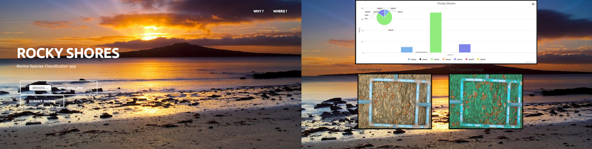
The DSIDE Rocky Shore team was tasked with creating an automated labelling tool that processes the photographs by identifying and classifying different groups of organisms in the photographs and calculating the % cover of the groups of organisms on the rocks. The team made use of machine learning techniques, in particular, convolutional neural networks, to create a trained model (classifier) for the image classification process. The classifier was then linked to a dashboard that allows a user to upload an image, classifies the image and produces the original image, the classified image and the % cover of organisms on the rocks as output. Below is an example of the dashboard: